Back>
Multispectral remote sensing in participatory on-farm variety trials (OK-Net Arable Practice Abstract)
Problem
In participatory on-farm variety trials, there is usually no possibility to set up a randomized, complete block design to collect eligible scientific results due to the lack of space, time and equipment of organic arable farmers.
Solution
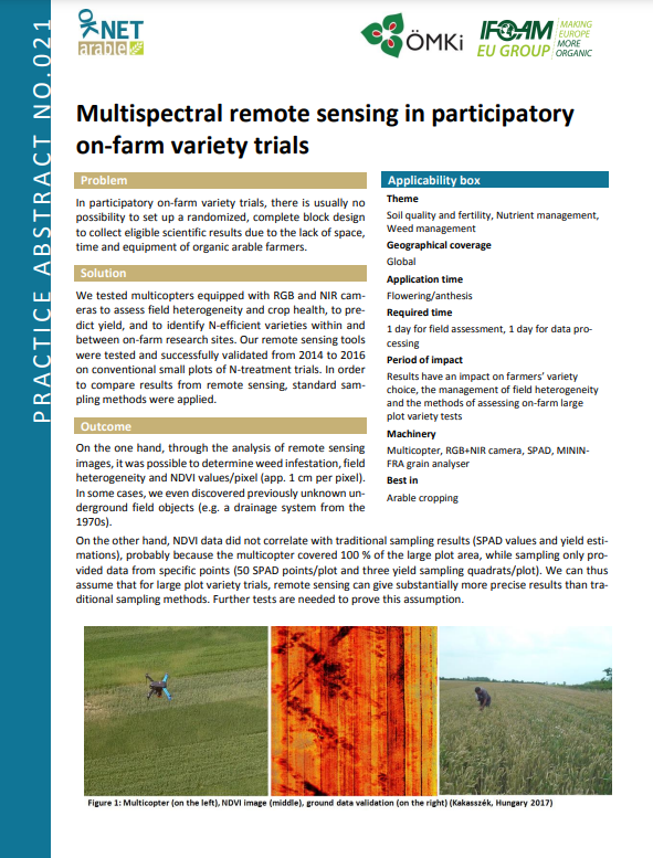
We tested multicopters equipped with RGB and NIR cameras to assess field heterogeneity and crop health, to predict yield, and to identify N-efficient varieties within and between on-farm research sites. Our remote sensing tools were tested and successfully validated from 2014 to 2016 on conventional small plots of N-treatment trials. In order to compare results from remote sensing, standard sampling methods were applied.
Description
On the one hand, through the analysis of remote sensing images, it was possible to determine weed infestation, field heterogeneity and NDVI values/pixel (app. 1 cm per pixel). In some cases, we even discovered previously unknown underground field objects (e.g. a drainage system from the 70s).
On the other hand, NDVI data did not correlate with traditional sampling results (SPAD values and yield estimations), probably because the multicopter covered 100 % of the large plot area, while sampling only provided data from specific points (50 SPAD points/plot and three yield sampling quadrats/plot). We can thus assume that for large plot variety trials, remote sensing can give substantially more precise results than traditional sampling methods. Further tests are needed to prove this assumption.
Practical recommendations
• A multicopter with a RGB and NIR camera was tested on four organic on-farm research sites in Hungary. Farm-scale plots (cc. 120 m2 per variety) were set up with 8 to 15 winter wheat varieties per farm.
• Data collection was performed at flowering/anthesis, on a sunny day, between 11 am and 1 pm (sun position, wind and clouds can highly affect image capturing).
• Ground data validation (chlorophyll readings (SPAD) from 50 randomly selected flag leaves/plot), phytopathology and weed bonitation were performed at the same time as image capturing (<1 cm resolution).
• 3 x 1 m2 yield sampling squares per plot were collected at harvest for quantitative and qualitative yield estimation.
• Validation sample numbers (SPAD, squares) were most probably too small to assess field heterogeneity correctly and to validate remote sensing (NDVI-Normalized Difference Vegetation Index) results.
Disqus
In order to use the comment function, you must register with the third-party provider "Disqus".
When you activate this function, your browser establishes a direct connection with the servers of the third-party provider. We would like to point out that data is transmitted to the third-party provider after activation, and the latter may set cookies that can also be used for analysis and marketing purposes. For more information, please refer to our privacy policy.
Activate